
How much does your site change year to year? 95West Aerial acquires repeat aerial imagery and lidar scans to document those changes visually and quantitatively. We publish the results to a secure public or private website so stakeholders can explore the imagery and compare orthophotos to lidar detail. Our team handles data capture, processing, and web delivery so you get accurate, easy‑to‑see change detection.
You can compare imagery side‑by‑side over time or view the changes through aerial mapping technology like lidar or multispectral imagery. The following are examples completed for a variety of municipalities or private companies.
Track Development Progress:
95West flew over the Minneapolis/St. Paul International Airport to document the recent expansion of Terminal 2, the Hubert H. Humphry Terminal serving regional and smaller international airlines. Comparing the imagery from 2024 and 2025, you can clearly see the detailed changes before and after the construction and new development.


Emergency Response Documentation:
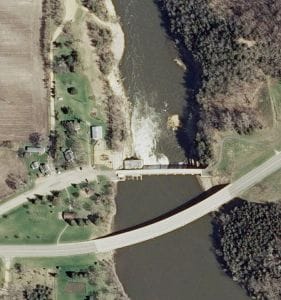
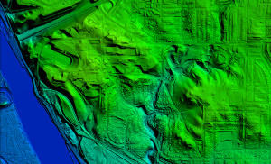
95West was contacted by Blue Earth County to document the damage from the partial failure of Rapidan Dam near Mankato, MN. 95West combined aerial images with lidar data to create a three-dimensional model to document the damage near the dam and the erosion from the Blue Earth River flooding in June 2024. Using the slider on the website, you can clearly see the change in landscape from before and after the extreme rain weather event.

Lidar and Photo Overlay:
95West pioneered simultaneous large-format imagery and high-density lidar collection onboard our Cessna Grand Caravan fixed wing airplane. Our team can collect imagery and data covering vast areas on a single flight that would take sUASs (Small Unmanned Aerial Systems) or UAVs (unmanned aerial vehicles or drones) weeks of work and multiple flights. Simultaneous collection with side-by-side synchronized gyroscopic mounted sensors maximizes efficiency during acquisition processing to deliver your aerial mapping solutions quicker and with greater accuracy.

Transportation Documentation:
95West documented the CSAH 8 Roundabout development for Douglas County starting in 2019 by flying the intersection before the roundabout construction began. 95West flew the site multiple times during construction. A final flyover was done after everything was completed to create an as-built model from combined lidar and aerial imagery to make a Digital Terrain Model (DTM) of the intersection.


The key to collecting and showing these incremental changes within a wide variety of data formats is that 95West uses simultaneous collection of lidar and high-resolution imagery. 95West’s large-format sensors ensure ultra-wide area coverage and high point density, capturing more data in less time with fewer flight lines.
For more information on our professional staff, equipment, and mapping solutions, please use the Contact Us page on our website.


